Data Archival & Backup for Emergency Preparedness
Introduction Simulations of emergency scenarios due to powerful artificial intelligence like AGI (Artificial General Intelligence)…
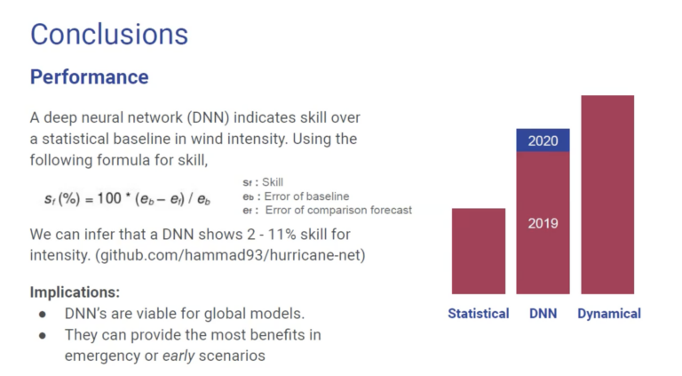
deep learning and artificial intelligence for global tropical storm forecasting


Introduction Simulations of emergency scenarios due to powerful artificial intelligence like AGI (Artificial General Intelligence)…

Edge AI requires that the artificial intelligence calculates their responses either on your device or…

AI was not used to generate any content or code. Any assistance was for grammar…

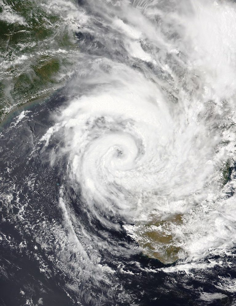
Overview of the 2024 Hurricane Season As the 2024 Atlantic hurricane season approaches its conclusion,…

Introduction Simulations of emergency scenarios due to powerful artificial intelligence like AGI (Artificial General Intelligence) describe increased cyberattacks that elevate the risk of cloud data infrastructure. Our experimental specialty consists of deep learning models that forecast extreme weather events such as hurricanes so offline media like M-Disc stores our data as part of our disaster…

Edge AI requires that the artificial intelligence calculates their responses either on your device or near the edge. Our recent developments have successfully engineered technology that achieves this goal while also alleviating environmental and safety concerns. After half a year of benchmarking, performance tuning, and monitoring, there is enough data to draw conclusions and publish…

AI was not used to generate any content or code. Any assistance was for grammar and proofreading. While the official Atlantic hurricane season begins on June 1st and ends on November 30th, does every day have an equal chance of a severe hurricane? If not, on which days are they most active? These are questions…

Overview of the 2024 Hurricane Season As the 2024 Atlantic hurricane season approaches its conclusion, it is essential to assess the predictions made at the beginning of the season against the actual outcomes. The National Oceanic and Atmospheric Administration (NOAA) forecasted an above-normal season with an 85% probability, anticipating between 17 to 25 named storms,…

We are excited to present our interactive global storm tracking map, available at https://fluids.ai/map/. This platform is built to provide real-time tracking of global storms, including Hurricane Milton, a Category 5 storm that recently made landfall as a Category 3 storm near Florida’s west coast. Using advanced satellite imagery and data feeds, users can monitor…

“The No. 1 killer in all of these storms is water” Deanne Criswell, Federal Emergency Management Agency’s administrator The 2023 Atlantic Hurricane Season was devastating, with peak winds of 145 knots (166.86 mph), based on NOAA’s HURDAT2 data. The analysis utilizes the Saffir-Simpson scale to categorize storms, with Category 5 hurricanes like Lee representing the…

In the vanguard of meteorological innovation, ‘hurricane-tts‘ emerges as a monumental integration of advanced technologies, setting new standards in delivering critical storm alerts. At its core, the project harnesses the massively multilingual Text-to-Speech capabilities from Facebook AI Research (FAIR), transforming weather data into spoken word with unparalleled linguistic diversity. Coupled with the analytical prowess of…

Source Idalia, a Category 3 hurricane, made landfall with a relentless fury, submerging homes, transforming streets into rivers, and leaving a trail of destruction in its wake. As the Southeastern coastal states grappled with its aftermath, the unique path and sheer power of Hurricane Idalia challenged preconceived notions. They underscored the need for continued research…

Visualising the intensity and progression of hurricanes on digital platforms has seen an impressive upgrade. A diligent researcher has created a set of distinctive icons that represent the categories of the Saffir-Simpson Hurricane Wind Scale. They are hosted on a GitHub repository called hurricane-net and can be found here. These icons, interestingly, are not just…

Prompt Used: A satellite image of the Atlantic Hurricane Caption: A Satellite Image Of Hurricane Generated Via DALL-E The 2022 hurricane season was cataclysmic and one of the most potent events to be ever recorded. The National Oceanic and Atmospheric Administration (NOAA) recorded a total of 14 storms, out of which 8 turned into…